# Technical Document Extraction: Image Analysis
## Image Description
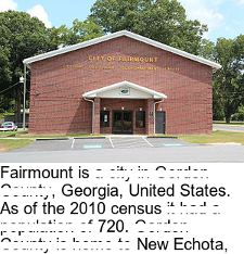
The image depicts a brick municipal building with a gabled roof. The structure features a central entrance with a covered portico. The building's facade includes a prominent sign with text. Surrounding the building are trees and a parking area with a single visible vehicle.
## Textual Content Extraction
### Primary Signage
- **Text:** "CITY OF FAIRMOUNT"
- **Font:** Yellow uppercase letters
- **Placement:** Top of the building facade
- **Additional Text:** Partially visible text below the main sign (obscured by redaction)
### Secondary Text Blocks
1. **First Block (Visible Portion):**
- "Fairmount is a city in Cobb County, Georgia, United States."
- "As of the 2010 census it had a population of 720."
2. **Second Block (Visible Portion):**
- "Cobb County is home to New Echota,"
- Remaining text redacted (represented by black blocks)
### Redaction Analysis
- Multiple sections of text are obscured by black rectangular blocks, preventing full transcription.
- Redacted content appears to continue the narrative about Fairmount and Cobb County.
## Structural Analysis
- **Building Type:** Municipal facility (likely city hall or administrative center)
- **Architectural Features:**
- Brick construction
- Gabled roof with white trim
- Covered entrance portico
- Parking area with handicap-accessible spaces
## Geographic Context
- **Location:** Fairmount, Cobb County, Georgia, United States
- **Population Data:** 720 residents (2010 census)
- **Regional Reference:** Cobb County (home to New Echota)
## Limitations
- Partial text visibility due to redaction
- No numerical data beyond population figure
- No visual charts/diagrams present
## Conclusion
The image provides limited textual information about Fairmount, Georgia, including its county affiliation, population statistics, and regional context. Critical details about the city's history or governance are obscured through redaction.