## Diagram: Deep and Wide Neural Network Architecture
### Overview
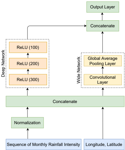
The image presents a diagram of a deep and wide neural network architecture designed for processing rainfall intensity data along with location coordinates. The network combines a deep branch with multiple ReLU layers and a wide branch with a convolutional layer and a global average pooling layer. The outputs of these branches are concatenated before feeding into the final output layer.
### Components/Axes
* **Input Layers (Blue):**
* Sequence of Monthly Rainfall Intensity
* Longitude, Latitude
* **Green Blocks:** Represent concatenation and normalization operations.
* Normalization
* Concatenate (x2)
* Output Layer
* **Deep Network (Left):** A series of ReLU layers.
* ReLU (300)
* ReLU (200)
* ReLU (100)
* **Wide Network (Right):** A convolutional layer followed by a global average pooling layer.
* Convolutional Layer
* Global Average Pooling Layer
* **Arrows:** Indicate the flow of data through the network.
### Detailed Analysis
1. **Input:** The network takes two inputs: a sequence of monthly rainfall intensity and the longitude/latitude coordinates.
2. **Normalization:** The rainfall intensity sequence is first normalized.
3. **Concatenation (Initial):** The normalized rainfall intensity is concatenated with the longitude/latitude data.
4. **Deep Network:** The concatenated data is fed into a deep network consisting of three ReLU layers with 300, 200, and 100 units, respectively.
5. **Wide Network:** The concatenated data is also fed into a wide network consisting of a convolutional layer followed by a global average pooling layer.
6. **Concatenation (Final):** The outputs of the deep and wide networks are concatenated.
7. **Output Layer:** The concatenated output is fed into the final output layer.
### Key Observations
* The architecture combines a deep network to capture complex temporal patterns in rainfall intensity with a wide network to incorporate spatial information from the location coordinates.
* The use of ReLU activation functions in the deep network helps to mitigate the vanishing gradient problem.
* The global average pooling layer in the wide network reduces the spatial dimensions of the convolutional layer output, making the network more robust to variations in input size.
### Interpretation
This deep and wide neural network architecture is designed to leverage both temporal and spatial information for rainfall prediction or analysis. The deep network is likely intended to learn complex patterns in the rainfall time series, while the wide network incorporates location-specific features. The concatenation of the outputs allows the model to integrate both types of information for improved performance. The architecture is suitable for tasks such as rainfall forecasting, drought monitoring, or flood risk assessment.