## Maze Navigation and Cognitive Tasks
### Overview
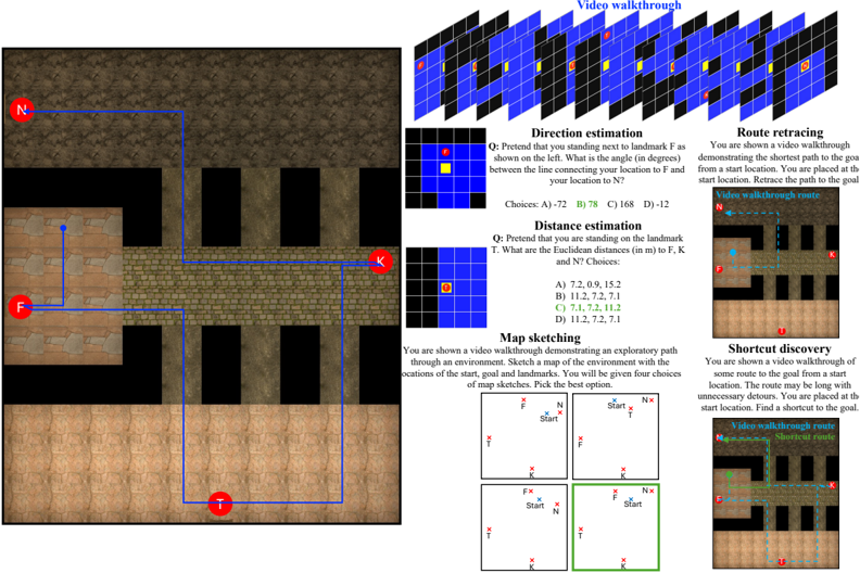
The image presents a series of cognitive tasks related to navigating a maze-like environment. It includes a visual representation of the maze, along with questions and scenarios involving direction estimation, distance estimation, map sketching, route retracing, and shortcut discovery. The image appears to be designed for assessing spatial reasoning and navigational abilities.
### Components/Axes
* **Maze Map:** A top-down view of a maze with walls and open pathways. Landmarks are marked with red circles labeled "N", "F", "K", and "T". A blue line indicates a path through the maze.
* **Video Walkthrough:** A series of frames depicting a first-person perspective video walkthrough of the maze.
* **Direction Estimation:** A question asking for the angle between the line connecting the user's location to landmark F and the user's location to N. A small grid shows the user's location (yellow) and landmark F (red).
* **Distance Estimation:** A question asking for the Euclidean distances from the user's location (landmark T) to landmarks F, K, and N. A small grid shows the user's location (red).
* **Map Sketching:** A task where the user is shown a video walkthrough and asked to sketch a map of the environment, choosing the best option from four provided sketches. One of the sketches is highlighted with a green border.
* **Route Retracing:** A scenario where the user is shown a video walkthrough and asked to retrace the shortest path to the goal from a start location. A small map shows the "Video walkthrough route" in blue.
* **Shortcut Discovery:** A scenario where the user is shown a video walkthrough of a longer route and asked to find a shortcut to the goal. A small map shows the "Video walkthrough route" and the "Shortcut route" in green.
### Detailed Analysis
* **Maze Map:** The maze consists of interconnected rooms and corridors. The path indicated by the blue line connects landmarks N, F, K, and T.
* **Direction Estimation:** The question asks for the angle between the user's location to F and the user's location to N. The choices are A) -72, B) 78, C) 168, D) -12.
* **Distance Estimation:** The question asks for the Euclidean distances from T to F, K, and N. The choices are A) 7.2, 0.9, 15.2; B) 11.2, 7.2, 7.1; C) 7.1, 7.2, 11.2; D) 11.2, 7.2, 7.1. Option C is highlighted in green.
* **Map Sketching:** Four map sketches are presented, each showing the relative positions of the start location, goal (N), and landmarks (F, K, T). The bottom-right sketch is highlighted in green, suggesting it is the correct answer.
* **Route Retracing:** The map shows the "Video walkthrough route" in blue, starting near N and ending near K.
* **Shortcut Discovery:** The map shows the "Video walkthrough route" and the "Shortcut route" in green, indicating a more direct path to the goal.
### Key Observations
* The image combines visual navigation with cognitive tasks.
* The tasks assess different aspects of spatial reasoning, including direction sense, distance estimation, and map creation.
* The use of video walkthroughs adds a dynamic element to the tasks.
* The highlighting of specific answers (distance estimation and map sketching) suggests a correct solution is being provided.
### Interpretation
The image presents a comprehensive assessment of spatial navigation and cognitive abilities within a virtual maze environment. The tasks require the user to integrate visual information from the maze map and video walkthroughs with their spatial reasoning skills to estimate directions, distances, sketch maps, and find optimal routes. The inclusion of multiple tasks suggests a multi-faceted approach to evaluating spatial intelligence. The highlighting of correct answers in some tasks may serve as a learning tool or a means of providing feedback to the user. The overall design indicates an attempt to simulate real-world navigation challenges in a controlled and measurable setting.