\n
## Diagram: Spatial Reasoning Tasks
### Overview
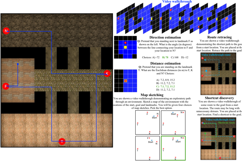
The image presents a collection of spatial reasoning tasks, visually represented with diagrams and accompanying text questions. The tasks involve direction estimation, distance estimation, map sketching, route retracing, and shortcut discovery, all within a simulated environment resembling a brick wall. The diagram is divided into several sections, each focusing on a specific task.
### Components/Axes
The diagram is composed of the following sections:
* **Top Section:** "Video walkthrough" - A grid of small images representing a video sequence.
* **Left Section:** A 2D representation of a brick wall with landmarks labeled 'F', 'N', and 'T'.
* **Center-Left Section:** "Direction estimation" - A question and multiple-choice answers.
* **Center Section:** "Distance estimation" - A question and multiple-choice answers.
* **Bottom-Left Section:** "Map sketching" - Four map options with start, goal, and landmark locations.
* **Center-Right Section:** "Route retracing" - A video walkthrough demonstrating the shortest path.
* **Right Section:** "Shortcut discovery" - A video walkthrough demonstrating a route with potential shortcuts.
### Detailed Analysis or Content Details
**Left Section (2D Map):**
* Landmark F is positioned on the left side of the image.
* Landmark N is positioned on the top-left side of the image.
* Landmark T is positioned on the bottom-left side of the image.
* A blue line connects Landmark F to Landmark N.
* A red line connects Landmark F to Landmark T.
**Direction Estimation:**
* **Question:** "Pretend that you are standing next to landmark F as shown on the left. What is the angle (in degrees) between the line connecting your location to F and your location to N?"
* **Choices:** A) -72, B) -78, C) 168, D) -12
**Distance Estimation:**
* **Question:** "Pretend that you are standing on the landmark T. What are the Euclidean distances (in m) to F, K and N? Choices:"
* **Choices:** A) 7.2, 0.9, 15.2, B) 11.2, 7.2, 7.1, C) 7.1, 7.2, 11.2, D) 11.2, 7.2, 7.1
**Map Sketching:**
* **Question:** "You are shown a video walkthrough demonstrating an exploratory path through an environment. Sketch a map of the environment with the locations of the start, goal and landmarks. You will be given four choices of map sketches. Pick the best option."
* Four map options are presented, each showing the relative positions of "Start", "F", "N", and "T".
**Route Retracing:**
* **Text:** "You are shown a video walkthrough demonstrating the shortest path to the goal from a start location. You are placed at the start location. Retrace the path to the goal."
* A series of small images depict a video walkthrough of a path.
**Shortcut Discovery:**
* **Text:** "You are shown a video walkthrough with some route to the goal from a start location. The route may be long with unnecessary detours. You are placed at the start location. Find a shortcut to the goal."
* A series of small images depict a video walkthrough of a path, potentially with detours.
**Top Section (Video Walkthrough):**
* A grid of approximately 7x9 small images, likely representing frames from a video.
### Key Observations
* The tasks are designed to assess spatial reasoning abilities.
* The environment is consistently represented as a brick wall with specific landmarks.
* The questions require the user to apply geometric concepts (angles, distances) and map-reading skills.
* The video walkthroughs provide visual context for the tasks.
### Interpretation
The diagram illustrates a series of experiments or exercises aimed at evaluating human or artificial intelligence's spatial reasoning capabilities. The tasks progressively increase in complexity, starting with simple angle and distance estimations and moving towards more complex map sketching and route planning. The use of a consistent environment (the brick wall) allows for controlled comparisons between different approaches to spatial reasoning. The inclusion of video walkthroughs suggests a focus on dynamic environments and the ability to learn from observation. The questions are designed to test the ability to translate visual information into quantitative measurements (angles, distances) and to create mental representations of the environment. The "shortcut discovery" task highlights the importance of efficient path planning and the ability to identify and exploit opportunities for optimization. The overall goal appears to be to understand how individuals or agents perceive, represent, and navigate spatial environments.