## Flowchart: Method Comparison for Airport-Country Reasoning
### Overview
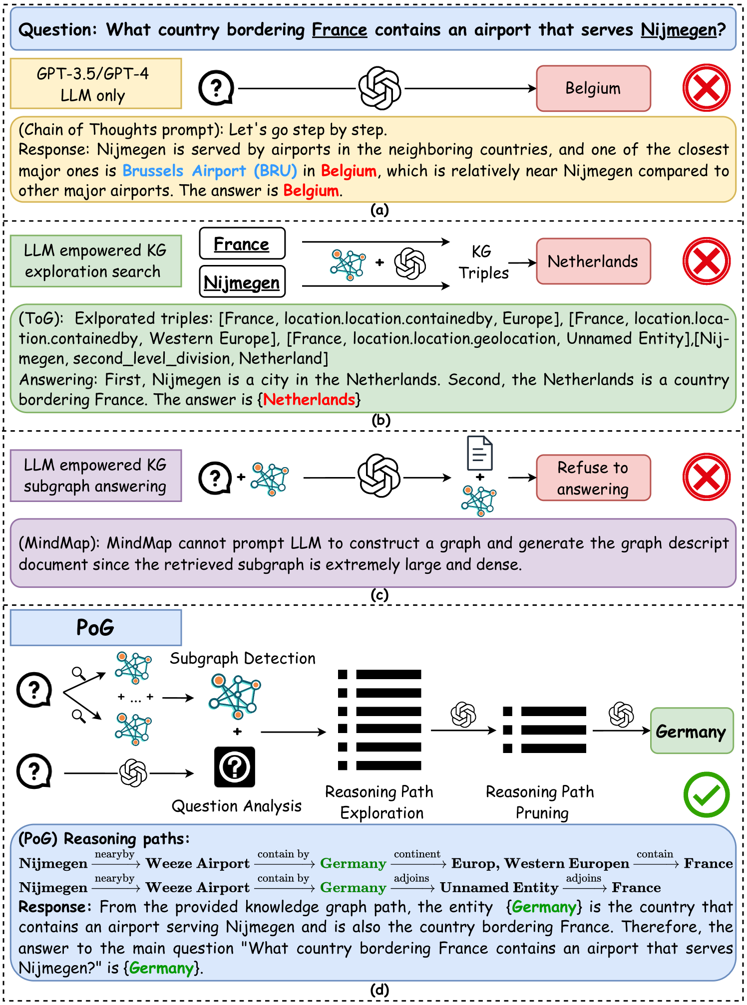
The diagram compares four methods for answering the question: "What country bordering France contains an airport that serves Nijmegen?" Each section (a-d) demonstrates a different approach, highlighting reasoning paths, errors, and outcomes. The correct answer is Germany, but some methods incorrectly identify Belgium or the Netherlands.
---
### Components/Axes
1. **Sections (a-d)**:
- (a) GPT-3.5/GPT-4 with Chain of Thought (CoT) prompt
- (b) LLM empowered KG exploration search
- (c) LLM empowered KG subgraph answering
- (d) PoG (Proposed method)
2. **Visual Elements**:
- **Question Mark (?)**: Represents the input query.
- **Triple Arrows (→)**: Denote reasoning steps or relationships.
- **Red X**: Incorrect answers.
- **Green Check**: Correct answer.
- **Triple Entities**: Structured as [Entity, Relation, Entity] (e.g., [France, location.location.containedby, Europe]).
---
### Detailed Analysis
#### Section (a): GPT-3.5/GPT-4 (CoT Prompt)
- **Question**: "What country bordering France contains an airport that serves Nijmegen?"
- **Reasoning**:
- Nijmegen is served by airports in neighboring countries.
- Brussels Airport (BRU) in Belgium is the closest major airport.
- **Answer**: Belgium (❌ Incorrect).
- **Error**: Misidentifies Nijmegen's location (Nijmegen is in the Netherlands, not Belgium).
#### Section (b): LLM Empowered KG Exploration Search
- **Question**: Same as above.
- **Reasoning**:
- Exploited triples:
- [France, location.location.containedby, Europe]
- [France, location.location.geolocation, Unnamed Entity]
- [Nijmegen, second_level_division, Netherlands]
- Concludes: Netherlands (❌ Incorrect).
- **Error**: Confuses Nijmegen's country (Netherlands) with the country bordering France.
#### Section (c): LLM Empowered KG Subgraph Answering
- **Question**: Same as above.
- **Reasoning**:
- Attempts subgraph analysis but fails due to "extremely large and dense" subgraphs.
- Refuses to answer (❌).
- **Error**: Inability to process complex subgraphs.
#### Section (d): PoG (Proposed Method)
- **Question**: Same as above.
- **Reasoning**:
- **Subgraph Detection**: Identifies relevant subgraphs (e.g., airports near Nijmegen).
- **Reasoning Path Exploration**:
- Nijmegen → Weeze Airport (Germany) → Germany → Europe → France.
- Nijmegen → Weeze Airport (Germany) → Germany → Unnamed Entity → France.
- **Answer**: Germany (✅ Correct).
- **Key Insight**: Uses spatial reasoning (e.g., "nearby" airports) and containment hierarchies to isolate Germany as the correct answer.
---
### Key Observations
1. **Incorrect Answers**:
- Belgium (a) and Netherlands (b) are geographically adjacent to France but do not border it.
- LLM methods (a-c) fail due to flawed reasoning or subgraph complexity.
2. **Correct Answer**:
- Germany borders France and contains Weeze Airport, which serves Nijmegen.
3. **PoG Advantage**:
- Combines subgraph detection with reasoning path pruning to avoid irrelevant entities (e.g., Europe, Unnamed Entity).
---
### Interpretation
The diagram illustrates how structured reasoning and knowledge graph (KG) analysis improve accuracy in geospatial reasoning tasks. Traditional methods (a-c) struggle with:
- **Geographical Ambiguity**: Confusing nearby countries (Belgium/Netherlands) with bordering ones.
- **Subgraph Complexity**: Overwhelmed by dense KG structures.
PoG's success lies in:
- **Spatial Reasoning**: Leveraging "nearby" relationships to prioritize relevant airports.
- **Containment Hierarchies**: Using "contain by" and "adjoints" relations to isolate Germany as the bordering country.
This approach mirrors human cognitive processes, where contextual clues (e.g., airport proximity) and hierarchical knowledge (e.g., country borders) are integrated to resolve ambiguity.