\n
## Diagram: Rectangular Grid with Dimensions
### Overview
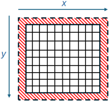
The image depicts a rectangular grid enclosed by a border. The border is highlighted with a pattern of red and blue dashes. The dimensions of the rectangle are labeled as 'x' and 'y', indicating width and height respectively. The grid itself consists of smaller, uniformly sized squares arranged in rows and columns.
### Components/Axes
* **Rectangle:** The main visual element, representing a two-dimensional space.
* **Border:** A dashed red and blue border surrounding the rectangle.
* **Grid:** A network of evenly spaced lines dividing the rectangle into smaller squares.
* **x-axis label:** "x" - positioned horizontally along the top edge of the rectangle, indicating width.
* **y-axis label:** "y" - positioned vertically along the left edge of the rectangle, indicating height.
* **Arrow:** Blue arrows indicating the direction of the x and y axes.
### Detailed Analysis or Content Details
The grid appears to be approximately 8 squares wide and 8 squares high, resulting in a total of 64 squares. The border is consistently spaced around the grid. The 'x' dimension is indicated by a horizontal blue arrow, and the 'y' dimension is indicated by a vertical blue arrow. The border consists of alternating red and blue dashes. The border is approximately one square wide.
### Key Observations
The diagram focuses on representing a rectangular area and its dimensions. The grid within the rectangle suggests a coordinate system or a discrete space. The border highlights the boundaries of the area. There is no numerical data provided beyond the labels 'x' and 'y'.
### Interpretation
This diagram likely represents a conceptual model of a two-dimensional space, potentially used in fields like computer graphics, image processing, or mathematics. The 'x' and 'y' labels suggest a Cartesian coordinate system. The grid could represent pixels in an image, cells in a matrix, or units in a spatial model. The border emphasizes the defined boundaries of the space. The diagram is a visual representation of a rectangular area with labeled dimensions, but it does not provide any specific data or values beyond the labels themselves. It is a foundational element for understanding spatial relationships and dimensions.