\n
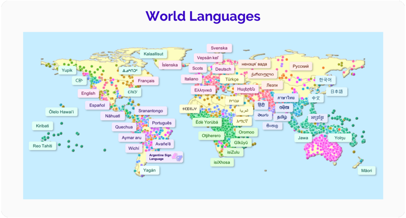
## Map: World Languages
### Overview
The image is a world map displaying the geographical distribution of various languages. Each language is represented by a colored dot or cluster of dots, and a label indicating the language name is placed near its primary area of usage. The map appears to be illustrative, showing approximate locations rather than precise linguistic boundaries.
### Components/Axes
The map itself serves as the primary component. There are no explicit axes, but the geographical coordinates (latitude and longitude) implicitly define the spatial arrangement. The languages are represented by different colored dots, and each language has a corresponding label.
### Detailed Analysis or Content Details
The following languages are identified on the map, along with their approximate locations:
* **English** (Pink): Primarily located in North America, the United Kingdom, Australia, and New Zealand.
* **Español** (Pink): Predominantly in Spain and South America.
* **Français** (Pink): Mainly in France, Canada, and parts of Africa.
* **Deutsch** (Yellow): Concentrated in Germany and surrounding areas.
* **Italiano** (Yellow): Primarily in Italy.
* **Русский** (Yellow): Predominantly in Russia and surrounding areas.
* **Türkçe** (Yellow): Mainly in Turkey.
* **العربية** (Yellow): Predominantly in the Middle East and North Africa. (Arabic)
* **中文** (Yellow): Primarily in China. (Chinese)
* **日本語** (Yellow): Primarily in Japan. (Japanese)
* **हिन्दी** (Yellow): Primarily in India. (Hindi)
* **Português** (Green): Predominantly in Portugal, Brazil, and parts of Africa.
* **Sranantongo** (Green): Located in Suriname.
* **Nahuatl** (Green): Located in Mexico.
* **Quechua** (Green): Located in the Andes region of South America.
* **Aymar aru** (Green): Located in the Andes region of South America.
* **Edé Yorùbá** (Green): Located in West Africa.
* **Oromo** (Green): Located in Ethiopia and surrounding areas.
* **Gikuyu** (Green): Located in Kenya.
* **isiZulu** (Green): Located in South Africa.
* **Jawa** (Purple): Located in Indonesia.
* **Yolngu** (Purple): Located in Australia.
* **Māori** (Purple): Located in New Zealand.
* **Reo Tahiti** (Purple): Located in French Polynesia.
* **Kiribati** (Purple): Located in Kiribati.
* **Olelo Hawai'i** (Purple): Located in Hawaii.
* **Wichi** (Pink): Located in Argentina.
* **Avafe'e** (Pink): Located in Argentina.
* **Argentine Sign Language** (Pink): Located in Argentina.
* **Yagan** (Pink): Located in Argentina.
* **ixthosa** (Green): Located in South Africa.
* **Ciw** (Pink): Located in the Philippines.
* **Kalaallisut** (Yellow): Located in Greenland.
* **Islenska** (Yellow): Located in Iceland.
* **Scots** (Yellow): Located in Scotland.
* **Vepsän kel'** (Yellow): Located in Russia.
* **Hwỳtßblu** (Yellow): Located in Russia.
* **עברית** (Yellow): Located in Israel. (Hebrew)
* **ไทย** (Yellow): Located in Thailand. (Thai)
* **ဗမာ** (Yellow): Located in Myanmar. (Burmese)
* **বাংলা** (Yellow): Located in Bangladesh. (Bengali)
* **অসমীয়া** (Yellow): Located in India. (Assamese)
* **Yupik** (Green): Located in Alaska.
The colors used are: Pink, Yellow, Green, and Purple. The distribution of languages appears to be clustered geographically, with certain regions dominated by specific language families.
### Key Observations
The map highlights the global diversity of languages. The concentration of languages in certain regions (e.g., Africa, South America, and Asia) suggests a rich linguistic history and cultural diversity in those areas. The map also shows the spread of major languages like English, Spanish, and French across continents, likely due to historical colonization and globalization.
### Interpretation
The map demonstrates the complex relationship between language, geography, and culture. The distribution of languages reflects historical migration patterns, colonial influences, and the natural barriers (mountains, deserts, oceans) that have shaped linguistic boundaries. The use of color-coding allows for a quick visual comparison of the prevalence of different language families across the world. The map is a simplified representation of a highly complex reality, as linguistic boundaries are often fluid and overlapping. The map suggests that while globalization is leading to the dominance of certain languages, a significant amount of linguistic diversity still exists, particularly in less-developed regions. The inclusion of sign languages (Argentine Sign Language) is a notable detail, acknowledging the importance of non-spoken forms of communication. The map serves as a visual reminder of the richness and fragility of human linguistic heritage.