## World Map: Geographic Distribution of Languages
### Overview
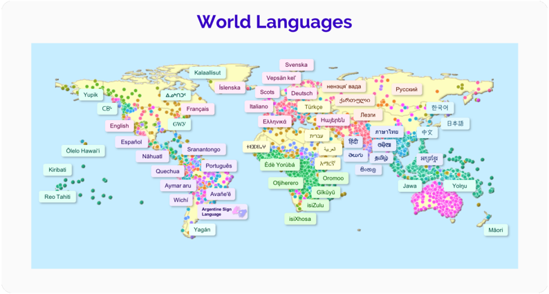
The image is a thematic world map titled "World Languages" that visualizes the approximate geographic locations of numerous languages across the globe. It uses a simplified continental outline as a base, overlaid with colored dots (primarily green, pink, and yellow) representing language locations and text labels identifying specific languages. The map does not provide a legend for the dot colors, nor does it include a scale, compass, or source citation. The primary information is the spatial distribution and naming of languages.
### Components/Axes
* **Title:** "World Languages" (centered at the top, in large, dark blue font).
* **Base Map:** A simplified political/physical world map showing continental outlines. No country borders are explicitly drawn.
* **Data Points:** Colored dots (green, pink, yellow) scattered across the landmasses, indicating the presence of a language.
* **Labels:** Text boxes with language names, placed near clusters of dots. The labels use various background colors (light pink, light green, light blue, light yellow) and text colors, but no key explains this coding. The labels are in the native script of the language where applicable.
### Detailed Analysis: Language Labels by Region
The following is a comprehensive list of all language labels visible on the map, grouped by approximate geographic region. Labels are transcribed exactly as they appear. Non-English labels are followed by an English translation in parentheses.
**North America & Caribbean:**
* Yupik
* Če (Cheyenne)
* English
* Español (Spanish)
* Nahuatl
* Olo Hawai'i (Hawaiian)
* Kiribati (Gilbertese)
* Reo Tahiti (Tahitian)
**South America:**
* Quechua
* Aymara aru (Aymara)
* Wichí
* Avañe'e (Guaraní)
* Argentine Sign Language
* Yagán
* Sránantongo (Sranan Tongo)
* Português (Portuguese)
**Europe:**
* Kalaallisut (Greenlandic)
* Íslenska (Icelandic)
* Français (French)
* Scots
* Deutsch (German)
* Italiano (Italian)
* Ελληνικά (Greek)
* Türkçe (Turkish)
* Svenska (Swedish)
* Vepsän ke'l (Veps)
* Русский (Russian)
**Africa:**
* አማርኛ (Amharic)
* እንግሊዝኛ (English - in Amharic script)
* Français (French)
* Español (Spanish)
* Português (Portuguese)
* Èdè Yorùbá (Yoruba)
* Ol'Chherero (Herero)
* Oromoo (Oromo)
* ʻOlelo Hawaiʻi (Hawaiian - appears misplaced in Africa)
* isiZulu (Zulu)
* isiXhosa (Xhosa)
* አማርኛ (Amharic - duplicate label)
* ስዋሂሊ (Swahili)
**Asia & Middle East:**
* Հայերեն (Armenian)
* ქართული (Georgian)
* हिन्दी (Hindi)
* বাংলা (Bengali)
* മലയാളം (Malayalam)
* தமிழ் (Tamil)
* ไทย (Thai)
* ລາວ (Lao)
* မြန်မာ (Burmese)
* ភាសាខ្មែរ (Khmer)
* Tiếng Việt (Vietnamese)
* 中文 (Chinese)
* 한국어 (Korean)
* 日本語 (Japanese)
* ភាសាខ្មែរ (Khmer - duplicate label)
* नेपाली (Nepali)
* සිංහල (Sinhala)
* ไทย (Thai - duplicate label)
* မြန်မာ (Burmese - duplicate label)
* ភាសាខ្មែរ (Khmer - duplicate label)
* Tiếng Việt (Vietnamese - duplicate label)
* 中文 (Chinese - duplicate label)
* 한국어 (Korean - duplicate label)
* 日本語 (Japanese - duplicate label)
**Oceania:**
* Jawa (Javanese)
* Yolŋu (Yolngu)
* Māori
### Key Observations
1. **High Density Regions:** The highest concentration of language labels and dots appears in Sub-Saharan Africa, South/Southeast Asia, and parts of South America (particularly the Andes and Amazon basin).
2. **Labeled vs. Unlabeled Dots:** Many colored dots, especially in North America, Northern Asia, and Australia, have no accompanying text label, indicating the map shows more language locations than it names.
3. **Label Placement:** Labels are generally placed near the associated dot cluster but are sometimes offset for readability, which can create minor ambiguity in precise location.
4. **Duplicate Labels:** Several language names appear more than once on the map (e.g., አማርኛ, ភាសាខ្មែរ,中文). This may indicate multiple distinct locations for the same language or a map design error.
5. **Script Variety:** The map effectively uses native scripts for many languages (e.g., Cyrillic, Greek, Armenian, Georgian, Devanagari, Bengali, Tamil, Thai, Khmer, Chinese characters, Hangul, Japanese).
6. **Absence of Legend:** The meaning of the different dot colors (green, pink, yellow) is not explained, limiting the analytical depth of the visualization.
### Interpretation
This map serves as a high-level visual inventory of global linguistic diversity. Its primary function is to demonstrate the vast number and wide geographic spread of the world's languages, moving beyond a simple list to show spatial relationships.
* **What it Demonstrates:** It powerfully illustrates that language diversity is not uniformly distributed but is concentrated in specific "hotspots" like tropical regions and mountainous areas. It also shows the global reach of colonial languages (English, Spanish, French, Portuguese) across multiple continents.
* **Relationships Between Elements:** The proximity of labels and dots creates a direct link between a language name and its approximate homeland. The clustering of dots and labels in certain areas visually argues for those regions being linguistically complex.
* **Notable Patterns & Anomalies:**
* **Outlier:** The label "ʻOlelo Hawaiʻi" (Hawaiian) appears in both the Pacific Ocean (correctly) and West Africa (likely an error).
* **Data Gap:** Large areas like central Australia, the Sahara, and northern Russia show dots but no labels, suggesting either a lack of specific language data for those points or a design choice to avoid overcrowding.
* **Political vs. Linguistic Space:** The map uses a continental base without political borders, emphasizing that languages exist in cultural-geographic spaces that often transcend modern nation-states.
**Conclusion:** The map is an effective educational tool for conveying the scale and distribution of human languages. However, its utility for detailed linguistic analysis is limited by the lack of a color legend, the absence of a scale, and some ambiguous label placements. It succeeds in its core mission: to make the abstract concept of "world languages" tangibly visible on a global canvas.