## Game Environment Navigation Tasks
### Overview
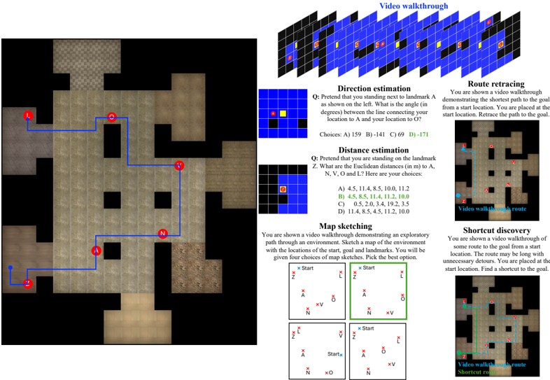
The image presents a series of tasks related to navigation within a game environment, likely for training or evaluation purposes. These tasks include direction estimation, distance estimation, map sketching, route retracing, and shortcut discovery. The image includes visual representations of the environment, questions related to navigation, and multiple-choice answers.
### Components/Axes
* **Game Environment Maps:** Several maps of the game environment are shown, with landmarks labeled as A, N, V, O, L, and Z.
* **Video Walkthrough:** A series of frames representing a video walkthrough are shown at the top-right.
* **Task Descriptions:** Textual descriptions of each task are provided.
* **Questions:** Each task includes a question related to the navigation challenge.
* **Multiple Choice Answers:** Each question is followed by multiple-choice answers (A, B, C, D).
### Detailed Analysis
**1. Video Walkthrough:**
* A sequence of frames, arranged in a grid, shows a first-person perspective of navigating the environment. The frames are primarily blue and black, with yellow and red markers indicating points of interest or landmarks.
**2. Direction Estimation:**
* **Question:** "Pretend that you standing next to landmark A as shown on the left. What is the angle (in degrees) between the line connecting your location to A and your location to O?"
* **Choices:**
* A) 159
* B) -141
* C) 69
* D) -171
* A small map shows the relative positions of the current location (yellow square) and landmark A (red square).
**3. Distance Estimation:**
* **Question:** "Pretend that you are standing on the landmark Z. What are the Euclidean distances (in m) to A, N, V, O and L? Here are your choices:"
* **Choices:**
* A) 4.5, 11.4, 8.5, 10.0, 11.2
* B) 4.5, 8.5, 11.4, 11.2, 10.0
* C) 0.5, 2.0, 3.4, 19.2, 3.5
* D) 11.4, 8.5, 4.5, 11.2, 10.0
* A small map shows the relative position of the current location (yellow square) and landmark Z (red square).
**4. Map Sketching:**
* **Description:** "You are shown a video walkthrough demonstrating an exploratory path through an environment. Sketch a map of the environment with the locations of the start, goal and landmarks. You will be given four choices of map sketches. Pick the best option."
* Four map sketches are presented, each showing the relative positions of the start point, goal (labeled as 'V'), and landmarks (A, N, O, L, Z). The second map sketch (top-right) is highlighted with a green border, suggesting it is the correct answer.
**5. Route Retracing:**
* **Description:** "You are shown a video walkthrough demonstrating the shortest path to the goal from a start location. You are placed at the start location. Retrace the path to the goal."
* A map of the environment is shown with a blue line indicating the shortest path from the start (labeled 'Z') to the goal (labeled 'L'). Landmarks A, N, and O are also marked on the map.
**6. Shortcut Discovery:**
* **Description:** "You are shown a video walkthrough of some route to the goal from a start location. The route may be long with unnecessary detours. You are placed at the start location. Find a shortcut to the goal."
* A map of the environment is shown with a green line indicating a shortcut route from the start (labeled 'Z') to the goal (labeled 'L').
### Key Observations
* The tasks are designed to assess spatial reasoning and navigation skills within a virtual environment.
* The map sketching task requires the participant to create a cognitive map of the environment based on a video walkthrough.
* The route retracing and shortcut discovery tasks involve identifying the optimal path between two points.
* The direction and distance estimation tasks test the participant's ability to estimate angles and distances within the environment.
### Interpretation
The image illustrates a comprehensive approach to evaluating navigation abilities in a virtual environment. The tasks cover a range of cognitive skills, including spatial awareness, memory, and problem-solving. The use of video walkthroughs and map representations provides a realistic and engaging context for the assessment. The multiple-choice format allows for objective scoring and analysis of performance. The tasks are likely part of a larger training or evaluation program aimed at improving navigation skills in virtual environments.