\n
## Spatial Reasoning Task: Environment Navigation
### Overview
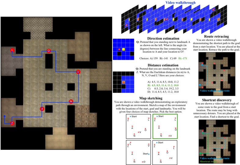
The image presents a collection of spatial reasoning tasks related to navigating a grid-based environment. It includes a central grid map, several question prompts with multiple-choice answers, and visual demonstrations of pathfinding concepts like shortest routes and shortcuts. The tasks assess skills in direction estimation, distance estimation, map sketching, route retracing, and shortcut discovery.
### Components/Axes
The image is divided into several sections:
* **Central Grid Map:** A 7x7 grid with colored squares (blue, red, yellow, green) representing different locations or landmarks. The grid has a path marked with a blue line. Landmarks are indicated by circular icons labeled 'A', 'N', 'O', and 'L'.
* **Video Walkthrough (Top):** A 3D isometric view of a similar grid environment, likely used as a visual aid for the tasks.
* **Direction Estimation:** A question prompt asking for the angle between two locations (A and O) on the grid. Choices are A) 159 B) 141 C) 69 D) 171.
* **Distance Estimation:** A question prompt asking for Euclidean distances (in m) between locations N, V, and L. Choices are A) 4.5, 11.4, 8.5, 10.0, 11.2 B) 4.5, 8.5, 11.4, 11.2, 10.0 C) 0.5, 2.0, 3.4, 19.2, 3.5 D) 11.4, 8.5, 4.5, 11.2, 10.0.
* **Map Sketching:** Four options for map sketches, each showing the start location, goal, and landmarks A, N, V, and O.
* **Route Retracing (Right):** A visual demonstration of retracing the shortest path from a start location to the goal, with a blue line indicating the route. The text reads "You are shown a video walkthrough demonstrating the shortest path to the goal from a start location. Retrace the path to the goal."
* **Shortcut Discovery (Bottom-Right):** A visual demonstration of finding a shortcut from a start location to the goal, with a green line indicating the shortcut. The text reads "You are shown a video walkthrough of some route to the goal from a start location. The route may be long with unnecessary detours. You are placed at the start location. Find a shortcut to the goal."
### Detailed Analysis or Content Details
**Central Grid Map:**
* The grid is 7x7.
* The path starts at the bottom-left corner and ends near the top-right corner.
* Landmark A is located at (1,0) (row 0, column 1).
* Landmark N is located at (5,1).
* Landmark O is located at (0,6).
* Landmark L is located at (6,6).
**Direction Estimation:**
* The question asks for the angle between locations A and O.
* The choices are: 159°, 141°, 69°, 171°.
**Distance Estimation:**
* The question asks for the Euclidean distances between N, V, and L.
* The choices are:
* A) 4.5, 11.4, 8.5, 10.0, 11.2
* B) 4.5, 8.5, 11.4, 11.2, 10.0
* C) 0.5, 2.0, 3.4, 19.2, 3.5
* D) 11.4, 8.5, 4.5, 11.2, 10.0
**Map Sketching:**
* Four map sketches are provided, each with a different arrangement of landmarks relative to the start and goal.
**Route Retracing:**
* The visual shows a blue line tracing a path through the grid.
**Shortcut Discovery:**
* The visual shows a green line representing a shortcut through the grid.
### Key Observations
* The tasks are designed to test spatial reasoning abilities in a grid-based environment.
* The visual aids (3D walkthroughs and grid maps) are intended to help participants understand the spatial relationships.
* The multiple-choice questions require participants to apply their spatial reasoning skills to estimate angles and distances.
* The map sketching task requires participants to create a mental representation of the environment and translate it into a visual form.
* The route retracing and shortcut discovery tasks assess participants' ability to find optimal paths through the grid.
### Interpretation
The image represents a comprehensive assessment of spatial reasoning skills. The tasks are interconnected, as understanding the environment (through the grid map and walkthroughs) is crucial for answering the questions and completing the challenges. The tasks progressively increase in complexity, starting with basic direction and distance estimation and culminating in more complex pathfinding tasks.
The inclusion of multiple-choice options suggests that the assessment is designed to be relatively objective. However, the map sketching task introduces a degree of subjectivity, as there may be multiple valid ways to represent the environment.
The visual demonstrations of route retracing and shortcut discovery highlight the importance of efficient pathfinding. The contrast between the longer route and the shortcut emphasizes the benefits of identifying and utilizing shortcuts to reach the goal more quickly.
The overall purpose of the assessment is likely to evaluate individuals' ability to navigate and reason about spatial environments, which is a valuable skill in many real-world applications, such as robotics, navigation, and urban planning. The tasks are designed to test both perceptual and cognitive aspects of spatial reasoning, including spatial awareness, mental rotation, and path planning.