# Technical Document Extraction: Ghana Telephone Numbering Plan Map
## 1. Document Overview
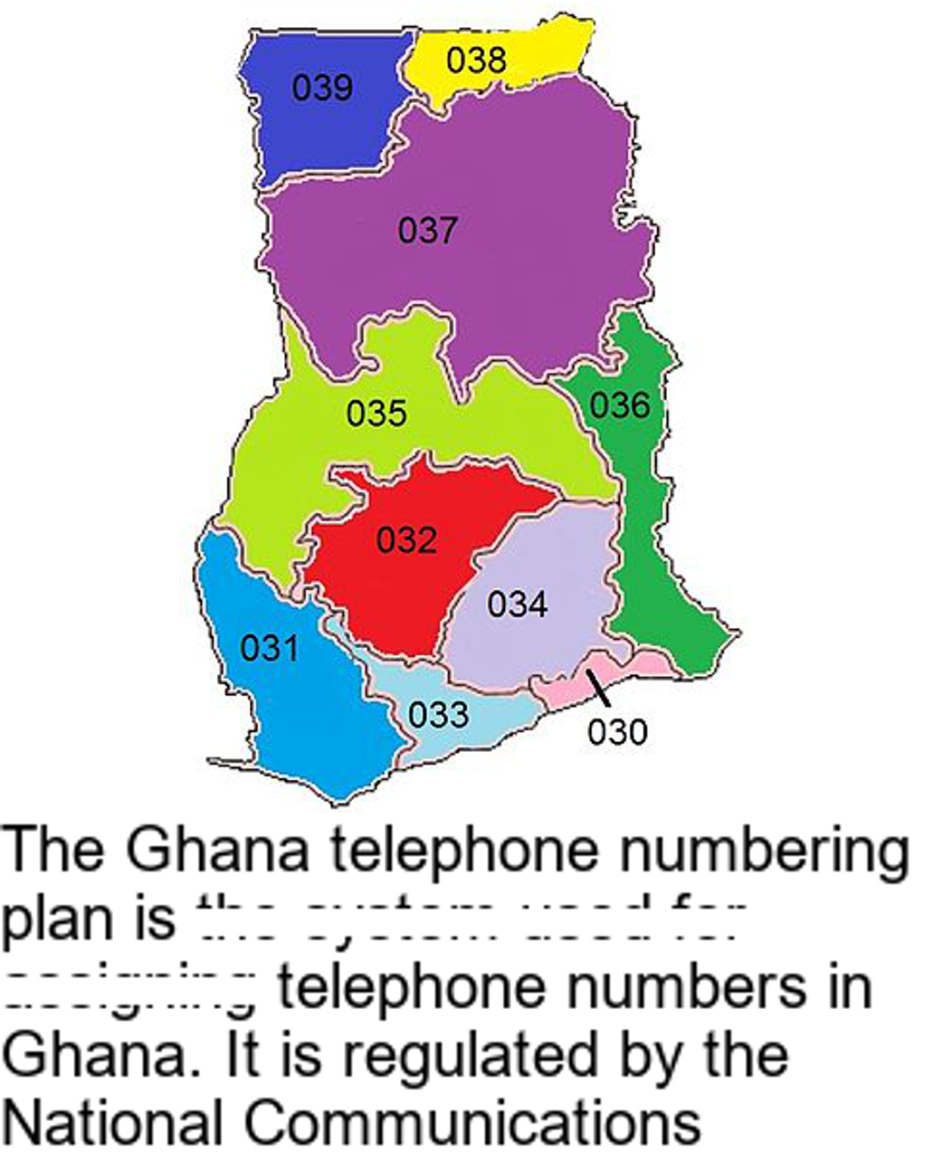
This image is a technical diagram illustrating the regional division of the Ghana telephone numbering plan. It consists of a color-coded map of Ghana with numerical area codes and a descriptive text block at the bottom.
## 2. Component Isolation
### Region A: Map Diagram
The map displays the geographic boundaries of Ghana, subdivided into ten distinct zones. Each zone is assigned a specific color and a three-digit numerical code.
#### Data Table: Regional Codes and Visual Identifiers
| Code | Color | Geographic Position |
| :--- | :--- | :--- |
| **030** | Pink | Southeast coastal strip (indicated by a leader line) |
| **031** | Light Blue | Southwest coast |
| **032** | Red | South-central interior |
| **033** | Pale Cyan | South-central coast (between 031 and 030) |
| **034** | Lavender | Southeast interior |
| **035** | Lime Green | Central-west interior |
| **036** | Dark Green | Eastern border (mid-section) |
| **037** | Purple | Large North-central region |
| **038** | Yellow | Northeast corner |
| **039** | Dark Blue | Northwest corner |
### Region B: Text Block (Transcription)
The text is located at the bottom of the image. Note: Some words in the second and third lines appear partially obscured or faded but are legible through context.
**Transcribed Text:**
> "The Ghana telephone numbering plan is the system used for assigning telephone numbers in Ghana. It is regulated by the National Communications"
*(Note: The text cuts off abruptly after "Communications", likely referring to the National Communications Authority (NCA) of Ghana.)*
## 3. Technical Analysis and Flow
The diagram functions as a spatial reference for landline or regional telecommunication routing.
* **Numerical Pattern:** All extracted codes follow a sequential prefix pattern starting with **03**. The third digit (0-9) differentiates the specific geographic region.
* **Spatial Distribution:**
* Codes **030-034** cover the southern half of the country.
* Codes **035-036** cover the central belt.
* Codes **037-039** cover the northern half of the country.
* **Visual Logic:** The use of high-contrast colors serves to clearly delineate administrative or technical boundaries that might otherwise overlap in a monochrome map.
## 4. Language Declaration
The primary and only language present in this document is **English**. No other languages were detected.