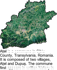
## Map with Descriptive Text: Ațel Commune, Romania
### Overview
The image consists of two primary components: a topographical map of a geographical region and a block of descriptive text below it. The map is a green-shaded relief map showing terrain features, with no visible labels, legends, or scales. The text provides administrative and compositional information about the location depicted.
### Components
1. **Map Component (Top):**
* **Type:** Topographical/relief map.
* **Visuals:** Depicts a landmass with varied shades of green, indicating elevation and terrain (likely hills and valleys). Lighter, yellowish-green patches are visible, which may represent settlements, agricultural areas, or different land cover. The overall shape is irregular, suggesting an administrative boundary.
* **Labels/Axes:** None present. No city names, rivers, roads, or coordinate markers are visible.
* **Legend:** None present.
2. **Text Component (Bottom):**
* **Position:** Located directly below the map, occupying the lower third of the image.
* **Language:** Romanian.
* **Font:** A standard serif typeface (e.g., Times New Roman).
* **Content:** A descriptive paragraph about the commune.
### Detailed Analysis / Content Details
**Text Transcription (Romanian):**
The visible text reads:
"Ațel este o comună în județul Sibiu, Transilvania, România.
Este compusă din două sate, Ațel și Dupuș. Comuna s-a..."
*(The text is cut off at the end of the line.)*
**English Translation:**
"Ațel is a commune in Sibiu County, Transylvania, Romania.
It is composed of two villages, Ațel and Dupuș. The commune first..."
**Map Visual Analysis:**
* The map shows a contiguous, roughly oval-shaped region with a jagged perimeter.
* The terrain appears hilly or mountainous, with darker green shading likely indicating valleys or lower elevations and lighter shades indicating ridges or higher ground.
* Several concentrated light-yellow patches are scattered within the region, with the largest one located slightly left of the center. These are inferred to be the built-up areas of the villages mentioned in the text (Ațel and Dupuș).
### Key Observations
1. **Information Asymmetry:** The map provides purely visual, unlabeled geographical context, while all specific factual data (name, location, composition) is contained in the text.
2. **Text Incompleteness:** The descriptive text is truncated, ending mid-sentence ("Comuna s-a..."), indicating that additional historical or administrative information is missing from the image.
3. **Lack of Cartographic Elements:** The map lacks standard reference points such as a north arrow, scale bar, coordinate grid, or labels for neighboring regions, rivers, or roads, limiting its standalone utility for precise geographical analysis.
4. **Visual-Textual Correlation:** The light patches on the map correspond logically to the "two villages" mentioned in the text, providing a visual representation of their approximate locations and relative sizes within the commune's territory.
### Interpretation
This image serves as a basic informational snippet, likely from an encyclopedia, textbook, or official document, introducing the Ațel commune. The data suggests the following:
* **Administrative Structure:** Ațel is a second-level administrative division (a commune) within Sibiu County, in the historical region of Transylvania, Romania. Its structure is composite, consisting of two distinct villages.
* **Geographical Context:** The commune encompasses a defined, hilly territory. The map visually communicates the physical landscape and the dispersed settlement pattern within its borders, even without labels.
* **Purpose and Limitation:** The combination of map and text is designed to give a quick, foundational understanding of "what and where" Ațel is. However, the cut-off text and lack of map details prevent a full understanding. The missing conclusion of the sentence ("Comuna s-a...") likely pertains to the commune's formation or first documented mention, which is a common format for such descriptions. To gain complete information, one would need to consult the full source document or a complete geographical database.