## Flowchart Diagram: American State Border Question Analysis
### Overview
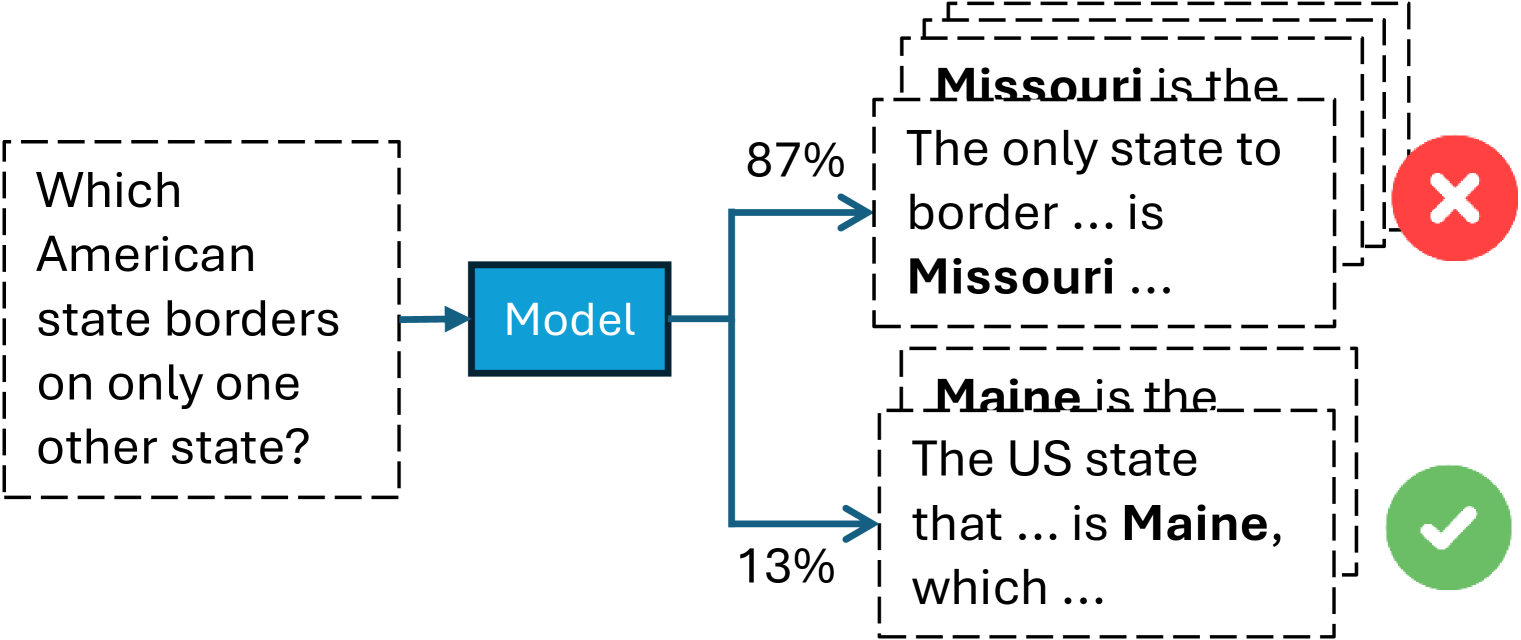
The diagram illustrates a decision-making process where a model evaluates a question about U.S. state borders. It shows two competing answers with confidence percentages and correctness indicators.
### Components/Axes
- **Input Box**: Contains the question "Which American state borders on only one other state?"
- **Model Box**: Central processing unit labeled "Model"
- **Output Boxes**: Two competing answers with:
- **Missouri**: 87% confidence (marked incorrect with red X)
- **Maine**: 13% confidence (marked correct with green checkmark)
- **Arrows**:
- Primary flow from question → model → answers
- Secondary flow from model → each answer with confidence percentages
### Detailed Analysis
1. **Question**: "Which American state borders on only one other state?"
2. **Model Processing**: Central node labeled "Model" with:
- 87% confidence arrow to Missouri answer
- 13% confidence arrow to Maine answer
3. **Answer Boxes**:
- **Missouri**:
- Text: "Missouri is the... The only state to border... is Missouri..."
- Incorrect (red X)
- **Maine**:
- Text: "Maine is the... The US state that... is Maine, which..."
- Correct (green checkmark)
### Key Observations
- **Confidence vs. Accuracy**: The model shows 87% confidence in the incorrect answer (Missouri) and only 13% in the correct answer (Maine)
- **Structural Flow**: Linear progression from question → model → branching to answers
- **Visual Hierarchy**:
- Red X (larger size) emphasizes incorrectness
- Green checkmark (smaller size) indicates correctness
- Confidence percentages decrease from left to right
### Interpretation
The diagram reveals a critical failure in model confidence calibration:
1. **Majority Confidence Fallacy**: The model's high confidence (87%) in Missouri suggests over-reliance on pattern recognition without contextual understanding
2. **Correctness Paradox**: Despite low confidence (13%), Maine is the factually correct answer
3. **Geographic Knowledge Gap**: The model appears to conflate Missouri's central location with border characteristics, while failing to recognize Maine's unique position as a northeastern state bordering only New Hampshire and Canada
This visualization highlights the importance of:
- **Confidence Calibration**: Models should not equate high confidence with correctness
- **Domain-Specific Knowledge**: Geographic questions require specialized reasoning beyond statistical patterns
- **Error Analysis**: The red X/green checkmark system provides immediate feedback on model performance