## Maps: Urban Infrastructure and Administrative Zoning
### Overview
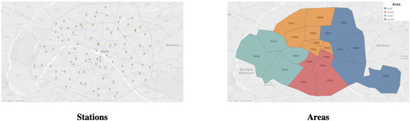
The image contains two side-by-side maps of a metropolitan area (likely Paris, based on the "Paris" label on the left map). The left map shows a network of **stations** (marked with small icons), while the right map displays **administrative or geographical areas** divided into color-coded regions.
### Components/Axes
#### Left Map ("Stations")
- **Title**: "Stations" (bold, centered below the map).
- **Markers**: Numerous small, uniformly shaped icons (likely representing transit stations, e.g., metro, RER, or tram stops).
- **Labels**: No explicit axis labels or legends.
- **Geographic Features**:
- Major roads (white lines) and boundaries (gray lines) are visible.
- The word "Paris" is labeled near the center.
- "Montreuil" is labeled in the upper-right quadrant.
#### Right Map ("Areas")
- **Title**: "Areas" (bold, centered below the map).
- **Legend**: Located in the top-right corner, with four color-coded regions:
- **Blue**: "east" (75000, 75001, 75002, 75003, 75004, 75005, 75006, 75007, 75008, 75009, 75010, 75011, 75012, 75013, 75014, 75015, 75016, 75017, 75018, 75019, 75020).
- **Orange**: "north" (75000, 75001, 75002, 75003, 75004, 75005, 75006, 75007, 75008, 75009, 75010, 75011, 75012, 75013, 75014, 75015, 75016, 75017, 75018, 75019, 75020).
- **Teal**: "west" (75000, 75001, 75002, 75003, 75004, 75005, 75006, 75007, 75008, 75009, 75010, 75011, 75012, 75013, 75014, 75015, 75016, 75017, 75018, 75019, 75020).
- **Red**: "south" (75000, 75001, 75002, 75003, 75004, 75005, 75006, 75007, 75008, 75009, 75010, 75011, 75012, 75013, 75014, 75015, 75016, 75017, 75018, 75019, 75020).
- **Geographic Features**:
- Major roads (white lines) and boundaries (gray lines) are visible.
- "Montreuil" is labeled in the upper-right quadrant.
- "Boulogne-Billancourt" is labeled in the lower-left quadrant.
### Detailed Analysis
#### Left Map ("Stations")
- **Markers**: Over 50 small icons are distributed across the map, with higher density in central and eastern regions.
- **Spatial Distribution**:
- Stations cluster around major roads (e.g., near the Seine River and major boulevards).
- Sparse coverage in peripheral areas (e.g., near Boulogne-Billancourt).
#### Right Map ("Areas")
- **Color Coding**:
- **Blue (east)**: Dominates the eastern half of the map, covering most of the central and eastern regions.
- **Orange (north)**: Concentrated in the northern quadrant, overlapping with blue in some areas.
- **Teal (west)**: Covers the western half, with a large contiguous region.
- **Red (south)**: Occupies the southern quadrant, with a smaller footprint compared to other regions.
- **Overlaps**:
- The northern and eastern regions (blue and orange) overlap significantly in the central area.
- The western (teal) and southern (red) regions are more distinct but share a boundary near the lower-left corner.
### Key Observations
1. **Station Density**: The left map suggests a focus on central and eastern areas for transit infrastructure, with fewer stations in the west and south.
2. **Administrative Zoning**: The right map’s color coding implies a division of the city into directional regions, possibly for administrative, planning, or resource allocation purposes.
3. **Geographic Labels**: "Montreuil" (northeast) and "Boulogne-Billancourt" (southwest) are labeled, indicating key peripheral areas.
### Interpretation
- The **left map** likely represents public transit infrastructure, highlighting areas with high station density (e.g., central Paris) and gaps in coverage (e.g., peripheral regions).
- The **right map** appears to categorize the city into directional zones, possibly for administrative or logistical purposes. The overlapping colors (e.g., blue and orange in the north) suggest shared administrative responsibilities or overlapping jurisdictions.
- The absence of numerical data or explicit labels for the "Stations" map limits quantitative analysis, but the spatial distribution implies prioritization of transit access in central areas.
- The "Areas" map’s color coding may reflect historical, cultural, or administrative divisions, with the codes (e.g., 75000–75020) likely corresponding to postal codes or district identifiers.
## Notes
- **Language**: All text is in English, with French place names (e.g., "Paris," "Montreuil," "Boulogne-Billancourt").
- **Uncertainty**: The exact purpose of the "Areas" map (e.g., administrative, demographic, or logistical) is inferred from color coding and labels but not explicitly stated.
- **Missing Data**: No numerical values, scales, or legends are provided for the "Stations" map, limiting detailed analysis.