## Qualitative Image Comparison Chart: Aerial Scene Reconstruction Methods
### Overview
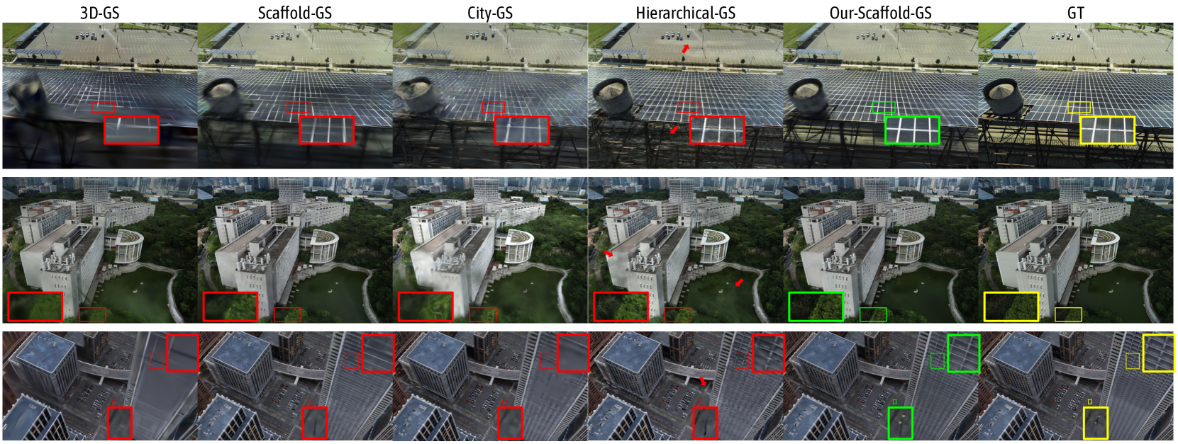
The image presents a side-by-side comparison of five different 3D reconstruction methods applied to aerial imagery, with a ground truth (GT) reference. Three rows show different scenes: a solar farm, an urban building complex, and a street-level view. Each method is evaluated using colored bounding boxes (red for errors/artifacts, green for accurate regions) to highlight reconstruction quality.
### Components/Axes
- **X-axis**: Five reconstruction methods:
1. 3D-GS
2. Scaffold-GS
3. City-GS
4. Hierarchical-GS
5. Our-Scaffold-GS
- **Y-axis**: Three scene categories:
1. Solar farm (top row)
2. Urban building complex (middle row)
3. Street-level view (bottom row)
- **Legend**:
- Red boxes: Artifacts/errors
- Green boxes: Accurate regions
- Yellow box: Ground truth (GT) reference
### Detailed Analysis
#### Scene 1: Solar Farm
- **3D-GS**: Red box highlights misaligned solar panel rows.
- **Scaffold-GS**: Red box shows missing panel sections.
- **City-GS**: Red box indicates distorted panel geometry.
- **Hierarchical-GS**: Red box marks panel misalignment; green box shows improved accuracy.
- **Our-Scaffold-GS**: Green box covers entire panel array; minimal red artifacts.
- **GT**: Yellow box confirms correct panel layout.
#### Scene 2: Urban Building Complex
- **3D-GS**: Red box highlights distorted building edges.
- **Scaffold-GS**: Red box shows missing roof details.
- **City-GS**: Red box indicates vegetation misclassification.
- **Hierarchical-GS**: Red box marks roof edge artifacts; green box shows improved building structure.
- **Our-Scaffold-GS**: Green box covers entire building complex; red box only on minor roof details.
- **GT**: Yellow box confirms accurate building geometry.
#### Scene 3: Street-Level View
- **3D-GS**: Red box highlights road surface artifacts.
- **Scaffold-GS**: Red box shows missing vehicle details.
- **City-GS**: Red box indicates tree canopy distortion.
- **Hierarchical-GS**: Red box marks road edge artifacts; green box shows improved vehicle rendering.
- **Our-Scaffold-GS**: Green box covers entire street view; red box only on minor vehicle details.
- **GT**: Yellow box confirms accurate street-level details.
### Key Observations
1. **Our-Scaffold-GS** consistently shows fewer red boxes (errors) and more green boxes (accurate regions) across all scenes compared to other methods.
2. **Hierarchical-GS** demonstrates partial improvements over baseline methods but still exhibits significant artifacts.
3. **3D-GS** and **Scaffold-GS** show the most severe reconstruction errors, particularly in complex geometries (solar panels, building edges).
4. **GT** serves as the ideal reference, with all methods failing to fully match its accuracy, though Our-Scaffold-GS comes closest.
### Interpretation
The data suggests that the proposed **Our-Scaffold-GS** method significantly improves 3D reconstruction quality by:
- Reducing geometric distortions in complex structures (solar panels, building facades)
- Better preserving small-scale details (vehicles, vegetation)
- Maintaining accuracy in both large-scale (urban layouts) and small-scale (street-level) scenes
Notable trends include:
- Methods using hierarchical processing (Hierarchical-GS) show incremental improvements over non-hierarchical approaches
- The scaffold-based approach (Our-Scaffold-GS) outperforms traditional 3D-GS and Scaffold-GS by addressing panel/building alignment issues
- All methods struggle with texture preservation in vegetated areas, as evidenced by persistent red boxes in green spaces
This comparison highlights the importance of scaffold-based processing and hierarchical refinement in achieving near-ground-truth reconstruction quality for aerial imagery.