# Technical Document Extraction: Appalachian Mountains Relation Analysis
## Diagram Overview
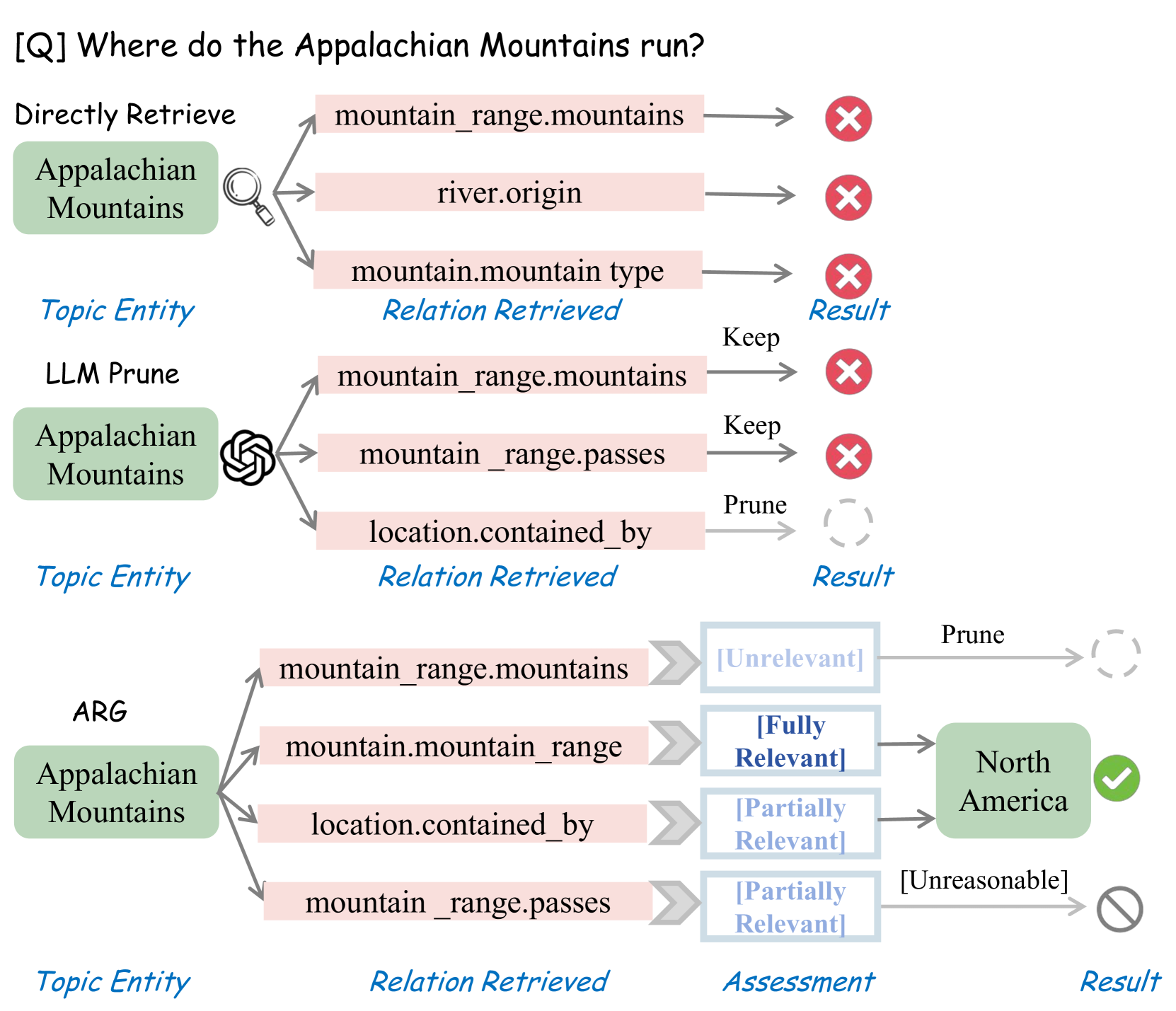
This flowchart illustrates the process of determining the geographical location of the Appalachian Mountains through three distinct analytical methods: **Directly Retrieve**, **LLM Prune**, and **ARG** (Argumentation-Based Reasoning). The diagram uses color-coded nodes and arrows to represent relationships, assessments, and final results.
---
## Key Components and Flow
### 1. **Directly Retrieve**
- **Topic Entity**: Appalachian Mountains (green box)
- **Relations Extracted**:
- `mountain_range.mountains` → ❌ (Red X: Rejected)
- `river.origin` → ❌ (Red X: Rejected)
- `mountain.mountain_type` → ❌ (Red X: Rejected)
- **Result**: No valid relations retained. Final output: `Result` (empty state).
---
### 2. **LLM Prune**
- **Topic Entity**: Appalachian Mountains (green box)
- **Relations Extracted**:
- `mountain_range.mountains` → ✅ (Kept)
- `mountain_range.passes` → ✅ (Kept)
- `location.contained_by` → ❌ (Pruned: Dashed arrow)
- **Result**: Partial retention of relations. Output: `Result` (no explicit value).
---
### 3. **ARG (Argumentation-Based Reasoning)**
- **Topic Entity**: Appalachian Mountains (green box)
- **Relations Extracted**:
- `mountain_range.mountains` → [Unrelevant] (Gray box)
- `mountain.mountain_range` → [Fully Relevant] (Blue box)
- `location.contained_by` → [Partially Relevant] (Blue box)
- `mountain_range.passes` → [Unreasonable] (Gray box)
- **Assessment Logic**:
- `mountain.mountain_range` → Fully Relevant → **North America** (Green checkmark)
- `location.contained_by` → Partially Relevant → Cross-referenced with `mountain_range.mountains` (Unrelevant) → Final output: **North America**.
- `mountain_range.passes` → Unreasonable → ❌ (Rejected).
---
## Diagram Structure
### Spatial Grounding
- **Legend**: No explicit legend present. Color coding is implicit:
- **Red X**: Rejected relations.
- **Green Checkmark**: Valid result.
- **Gray Box**: Unrelevant/pruned relations.
- **Blue Box**: Fully/Partially Relevant relations.
### Flowchart Segmentation
1. **Header**: Question `[Q] Where do the Appalachian Mountains run?`
2. **Main Chart**:
- **Directly Retrieve**: Top-left quadrant.
- **LLM Prune**: Middle quadrant.
- **ARG**: Bottom-right quadrant.
3. **Footer**: Final result (`North America`) with green checkmark.
---
## Key Trends and Data Points
- **Directly Retrieve**: All relations rejected due to lack of direct relevance.
- **LLM Prune**: Pruned `location.contained_by` but retained `mountain_range` relations.
- **ARG**:
- `mountain.mountain_range` identified as **Fully Relevant**.
- `location.contained_by` deemed **Partially Relevant** but cross-validated.
- `mountain_range.passes` rejected as **Unreasonable**.
---
## Final Result
The Appalachian Mountains are located in **North America**, as determined by the ARG method through cross-validation of relation relevance.
---
## Notes
- No non-English text present.
- Diagram uses symbolic representation (✅, ❌, dashed arrows) to denote relation status.
- No numerical data or heatmap categories; purely categorical and logical flow.