## Map: Ațel Commune, Sibiu County, Transylvania, Romania
### Overview
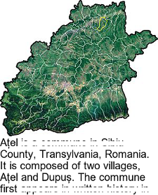
The image is a map of the Ațel commune located in Sibiu County, Transylvania, Romania. The map shows the geographical layout of the commune, including its villages and surrounding areas. The map is satellite imagery with borders drawn on top.
### Components/Axes
* **Location:** Ațel Commune, Sibiu County, Transylvania, Romania.
* **Villages:** Ațel and Dupuş.
* **Visual Elements:** Satellite imagery showing terrain, vegetation, and possibly some infrastructure. A yellow border highlights a specific region in the northern part of the commune.
### Detailed Analysis
The map displays the geographical boundaries of the Ațel commune. The satellite imagery provides a detailed view of the landscape, showing variations in terrain and vegetation cover. The yellow border highlights a specific area within the commune, possibly indicating a point of interest or a specific administrative region.
The text below the map states that the commune is composed of two villages, Ațel and Dupuş.
### Key Observations
* The map provides a visual representation of the Ațel commune's location and geographical features.
* The yellow border highlights a specific area within the commune.
* The text identifies the two villages that make up the commune.
### Interpretation
The map serves as a visual aid for understanding the geographical context of the Ațel commune. It shows the location of the commune within Sibiu County, Transylvania, Romania, and highlights its key features, such as its villages and terrain. The yellow border may indicate a specific area of interest within the commune, such as a protected area or a development zone. The map and text together provide a basic overview of the commune's composition and location.